|
Day: |
075 |
|
Date: |
Tuesday, 7 June 2016 |
|
Start: |
Ballycastle |
|
Finish: |
Glenariff Forest Park |
|
Daily
Kilometres: |
30 |
|
Total
Kilometres: |
2071 |
|
Weather: |
Heavy overcast, humid, rain showers,
thunderstorms in the afternoon |
|
Accommodation: |
Riverside B&B, Cushendall |
|
Nutrition: |
Breakfast: Full Irish Breakfast
Lunch: Muesli bars, Snickers Bars and chocolate
Dinner:
Doner kebab, salad & chips, fruit trifle |
|
Aches: |
None |
|
Highlight: |
Remote and wild countryside on a stormy
afternoon around Slieveanorra. |
|
Lowlight: |
Being eaten alive by bugs during my first
break. |
|
Pictures: |
Here |
|
GPS Track: |
Here |
|
Journal: |
I had a 7am breakfast with the idea of
giving myself plenty of hiking time. My plan A was to follow
the Moyle Way south from Ballycastle until I reached the A43 main
road, a distance of 30km, and to then catch either the 4:16pm or
6:16pm bus to Cushendall on the northwest coast where I had a B&B
booked. Plan B was that if I felt good enough when I reached
the A43, I could continue hiking another 12km to Cushendall which
was just beyond the end of the Moyle Way and have less to do
tomorrow. Barclay, the friendly and interested B&B owner, said
he had hiked the Moyle Way many years ago and that it had a
reputation for being very boggy. He also said that a recent
hiker had told him there were a lot of trees down on the trail.
I started walking at 8am and was soon out of town and on a
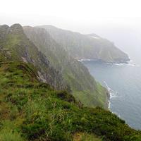
forestry road climbing through Ballycastle Forest onto the shoulder
of Knocklayd Mountain. It was very gloomy, humid and buggy and
rain seemed imminent, but it was too warm to don my wet weather gear
as a precaution. My trail wound around the side of the
mountain with some hazy views back to the ocean and Rathlin Island,
and then joined a rural back road for a few kilometres before
entering another forest. I had my first break in light rain,
but ended up cutting it short because I was being attached by swarms
of midges.
On resuming, the walking was initially easy, but
then the Moyle Way turned onto a rough foot trail which became boggy
and then entered an area where there were many trees down. It
was slow going and for one 100 metre section I had to take my pack
off and push it ahead of me through gaps in the fallen trees trying
not to tear my raincover. The trail eventually emerged onto a
farm road in a remote valley for a few kilometres and then returned
to a rough forest trail. Progress was slow and the 4:16pm bus
seemed an unlikely prospect. I took a second break where I
emerged from the forest on a back road and then began a steady climb
on a little-used stony road up Slieveanorra Mountain (561m) from the
top of which I had good views across moorland and forests, despite
the low cloud, rain and haze.
Past the summit, the Moyle Way
followed a faint trail across boggy moorland towards a distant
forest. I was glad the previous week had been warm and dry,
because the bogs were bad enough. In a wet period it would
have been a real slog. Walking across the bogs, you are
constantly trying to work out what will support your weight, and
after a while you get pretty good at judging. The problem is,
that you only have to be wrong 1% of the time, to go up to your calf
in the slop, and the damage is done.
Thunderstorms and rain
became heavier during this slog and I vacillated about putting on my
wet weather gear. As a compromise, I put my gaiters on which
gave some protection against the bogs but also prevented the rain
wetting my socks and the inside of my boots. Thunder was all
around, and I was not keen to be on higher ground when lightning was
striking, but didn't really have the option of slowing down
(apparently three people were hit by lightning near Belfast during
the same storms).
Not for the first time during the day,
markers were missing at key junctions, and after the bog this
happened again. I made a turn that seemed required by the map
to begin climbing up onto Trostan Mountain and was gratified to find
a marker post a kilometre further on. With time being of the
essence, I was trying to navigate very carefully, and was pleased to
end the day without having gone off track.
The climb up
Trostan Mountain was virtually cross-country, boggy and slow work.
I began to assume I would miss the 6:16pm bus (the last for the day)
and have to hitch-hike to Cushendall. I became even more
pessimistic when the trail entered a boggy forest after descending
across the moorland. There were no markers for a long time in
the dark forest and I just hoped that the very rough trail I was
trying to follow was the right one. It was, and I eventually
emerged onto farmland and then crossed a road that I knew was only a
few kilometres before I reached the A43. I checked my watch
and still figured I would be lucky to catch the bus, particulary
since the ones I had caught so far always seemed to run a few
minutes ahead of schedule. Anyway, I strode out, determined to
give it my best shot, and reached the road at 6:13pm. I just
had time to take the rain cover off my pack, about 30 seconds, when
around the corner came the bus. I stuck my hand out, it
stopped, and I bought a ticket to Cushendall. I could not
believe my luck as I sat in the bus and enjoyed the drive.
My
B&B is in the middle of the village and I checked in, had a shower
and got some dinner. It had been a long tiring day, but I had
seen some great country and enjoyed the challenging trail. |
|
ADVENTURE LIST
Round Ireland
(2016)
Hume & Hovell Walking Track
(2013)
Via Alpina
(2012)
Australian Alps Walking
Track
(2011)
Land's End to John O'Groats
(2010)
Round Oz Bike Record Attempt
(2009)
Round Oz Bike Record Attempt
(2008)
Round Oz Bike Record Attempt
(2007)
Australia Tip to Top MTB
(2006)
Adelaide to Darwin MTB
(2005)
Sydney to Melbourne MTB
(2004)
Three Peaks Race
(2004)
Appalachian Trail
(1986)
Alpine Track
(1983)
|