|
Day: |
019 |
|
Date: |
Tuesday, 12 April 2016 |
|
Start: |
Adrigole |
|
Finish: |
Allihies |
|
Daily
Kilometres: |
34 |
|
Total
Kilometres: |
576 |
|
Weather: |
Sunny all day with a cool wind at altitude. |
|
Accommodation: |
Seaview Guesthouse |
|
Nutrition: |
Breakfast: Full Irish Breakfast
Lunch: Jam tarts and ice-cream
Dinner: Hamburger,
chips and salad, and apple crumble and custard |
|
Aches: |
None really |
|
Highlight: |
From my B&B window, an exquisite sunset
over a calm Atlantic ocean, with orange rays illuminating white farm
houses along the peaceful Irish coast. |
|
Lowlight: |
When I asked my B&B hostess from last
night, as she was driving me back to Adrigole, why she did not have
her B&B sign out yet, hearing that her 38-y-o son had died four
weeks early without warning from an undiagnosed heart problem, and
that she was having trouble getting motivated for the new tourist
season. |
|
Pictures: |
Here |
|
GPS Track: |
Here |
|
Journal: |
I had breakfast at 8:00am and then Jane
drove me back to Adrigole, on the way relating the very sad tale of
how her son had died just four weeks ago, totally unexpectedly, from
an undiagnosed heart problem. It seemed an incongruously sad
story on such a beautiful spring morning.
I started walking
soon after 9:00am, somewhat apprehensive about the task I had set
myself for the day. Because of where accommodation was
available, I had to choose between a very short day and a very long
day, and chose the latter. The problem was that I really
wasn't sure how long the day was going to be. I knew it was
roughly 33 kilometres, but also knew that there was going to be a
lot of cross-country and mountain climbing, both of which made for
slow going. Oh well, I had booked the B&B and knew I would
eventually get there, it was just a question of when.
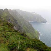
The day
started with a country-lane walk out of town before climbing up the
flank of Hungry Hill (685m), the local landmark. Wisely, I had
stripped to T-shirt and shorts before starting the climb because it
got warm. But the skies were clear and the views magnificent,
and I'm in the hiking groove now and can just keep plodding along
without getting overly tired. Once over the mountain flank, I
could see the town of Castletownbere in the distance, and behind
that, the mountains I had to negotiate to reach Allihies, my target
for the day. It seemed a very long way away, and I wasn't
taking the most direct route.
I then had quite a few hours of
crossing mostly track-less uplands pasture and exposed rock outcrops
following the little posts that marked the Beara Way. It was
boggy and scrambly in parts meaning that I was constantly looking
for the best line to take which can be time-consuming. But the
fantastic views and still and sunny conditions made it a very
pleasant hike.
I eventually reached the small port of
Castletownbere soon after 2:30pm and had my second break for the day
sitting by the harbour eating an ice-cream and downing a cold drink.
I was a bit later than I hoped, but was counting on the next section
being less challenging. I was wrong, and after an initial
roadwalk, I was soon climbing the flank of another mountain,
Miskish, and following the familiar posts cross-country. It
was very windy and quite cold when I reached a ridge and turned
southwest, but again the views were more than adequate compensation.
On descending from the ridge, I encountered a temporary sign
saying the Beara Way was closed. It was a bit late to tell me,
and I wasn't going to backtrack, so I continued on through a pine
forest that was being logged. There were a few parts where it
was extremely boggy and another where a number of felled trees lay
across the trail, but there was nobody about and I just negotiated
the obstacles as best I could.
It was starting to get late,
and I wasn't amused by the brutal hill that I next encountered,
climbing 210 metres vertically in 1.4 kilometres, but was pleased
with how quickly I reached the top. From there it was a more
gentle descent towards Allihies with a peaceful Atlantic and various
peninsulas and islands spread out before me. Magic!
I
reached my B&B right on 6:30pm, showered and then visited the local
pub for dinner (a bit over-priced) before retiring to my room happy
with my day, but a bit wiser about my average speed on the more
challenging country. I have now reached the most
south-westerly point of my journey and now start working my way
north along the west coast. |
|
ADVENTURE LIST
Round Ireland
(2016)
Hume & Hovell Walking Track
(2013)
Via Alpina
(2012)
Australian Alps Walking
Track
(2011)
Land's End to John O'Groats
(2010)
Round Oz Bike Record Attempt
(2009)
Round Oz Bike Record Attempt
(2008)
Round Oz Bike Record Attempt
(2007)
Australia Tip to Top MTB
(2006)
Adelaide to Darwin MTB
(2005)
Sydney to Melbourne MTB
(2004)
Three Peaks Race
(2004)
Appalachian Trail
(1986)
Alpine Track
(1983)
|