|
Day: |
012 |
|
Date: |
Tuesday, 5 April 2016 |
|
Start: |
Clogheen |
|
Finish: |
Fermoy |
|
Daily
Kilometres: |
40 |
|
Total
Kilometres: |
377 |
|
Weather: |
Cold to cool with a mix of sunshine and
cloud |
|
Accommodation: |
Abbeyville House B&B |
|
Nutrition: |
Breakfast: Full Irish Breakfast
Lunch: Biscuits and chocolate
Dinner: Spring rolls,
chicken and cashews, white rice, and tarts |
|
Aches: |
Feet sore again |
|
Highlight: |
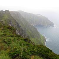
Crossing the higher elevations of Crow Hill
on a beautiful morning |
|
Lowlight: |
The B&B owner's dog jumping up on my pack
and tearing a hole (5cm) in my pack raincover as I left |
|
Pictures: |
Here |
|
GPS Track: |
Here |
|
Journal: |
I couldn't find a B&B closer than about
40km away after a long Google search last night, so knew I had
another long day in prospect. Georgina's dog was again making
a nuisance of herself while I had breakfast and then jumped up on
the back of my pack as I was leaving and I later discovered a new
tear in the pack cover. Not happy!
Apart from that,
however, I had a good morning. I've finished the Munster Way
and am now on the Blackwater Way (aka Avondhu Way) and the day
started with a gentle, but long climb on a little-used road,
initially through farms and old forests, and later up on to the
moors. it was a clear day, the walking was easy and I savoured
the views and solitude.
At the top of the climb, the trail
left the road and followed a rough path across the moors near the
top of Crow Hill. Although it was boggy underfoot, the going
was quite easy and the excellent views to the south continued.
Eventually the trail returned to farm paths and minor roads at a
lower elevation, but still pleasant walking.
By this time, my
feet were starting to complain, and sadly the scenery interest
declined at the same time. The next few hours were spent
trudging along endless relatively flat paths through pine
plantations. My focus began to be on how far I had to go, but
I've learnt that it's rarely less than I think, so I tried to be
realistic. Apparently, there is a military camp near Kilworth,
and at one point in the forest I encountered a Firing Range warning
sign, though my trail turned off to safety.
The scenery
improved as the trail followed a pretty stream through old growth
forest and I eventualy reached Kilworth, which I estimated to be
about 4km from my destination. Unnervingly, I saw a sign 15
minutes later saying it was 6 kilometres to Fermoy, but happily it
proved to be wrong. I finally entered the busy town of Fermoy
and found my B&B without trouble at 6:30pm. I was very happy
to finish.
After a shower I walked into the old town,
crossing the Blackwater River, and bought some Chinese take-out and
a few snacks for dinner. My feet are ready for a shorter day
tomorrow. |
|
ADVENTURE LIST
Round Ireland
(2016)
Hume & Hovell Walking Track
(2013)
Via Alpina
(2012)
Australian Alps Walking
Track
(2011)
Land's End to John O'Groats
(2010)
Round Oz Bike Record Attempt
(2009)
Round Oz Bike Record Attempt
(2008)
Round Oz Bike Record Attempt
(2007)
Australia Tip to Top MTB
(2006)
Adelaide to Darwin MTB
(2005)
Sydney to Melbourne MTB
(2004)
Three Peaks Race
(2004)
Appalachian Trail
(1986)
Alpine Track
(1983)
|