|
It was another cold night, though not too bad in the quaint old
hut. There was a heavy fog when I woke at 6:00am, but it had receded
down the valley by 7:00am revealing another cloudless sky.
I started walking at 8:00am and quickly covered the kilometer
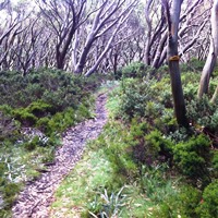
back to the AAWT and began following the route north along the same
closed and disused old 4WD tracks passing through alpine valleys and
over a few low ridges. I was close to the Mt Selwyn ski field and
there were a number of marked cross-country ski trails crossing the
trail at various points. I met a highway at the old mining town of
Kiandra, now uninhabited with just a few buildings remaining. There
is also a Roads Depot here and I have vivid memories of sheltering
inside it 7 years ago when caught in a November blizzard while
riding my MTB to Melbourne down the Bicentennial Trail.
I took my morning break at Kiandra and then continued on. I was
now back in brumby country and felt my nose watering and eyes
welling again in reaction to the horse droppings everywhere. Of
course, it's nice that there are wild horses in the mountains, but
they are feral and they do have a significant impact on the
landscape. I think that their numbers need to be controlled, but
know this is a sensitive issue.
The remainder of the day was spent walking from one long flat
alpine valley to another via low snowgum wooded hills. The average
altitude was about 1400m, but you couldn't tell from the terrain. It
had all been high country sheep or cattle stations at some point and
there was evidence of fences and gates here and there.
Around 3.30pm I deviated from the AAWT to go cross-country for a
couple of kilometers to the place where I had hidden my food drop
using my GPS. I hadn't been able to find a good hiding spot right on
the trail near here so had hidden it on the access track. I found it
without much trouble by 4:30pm and had a relaxing evening eating my
treats. I hear on the radio that my run of good weather will be
coming to an end tomorrow and I'll be wet for the last three days of
my trip.
|